Welcome to North Richland Hills, a highly connected suburb positioned right in the heart of the Dallas-Fort Worth metroplex. If you are looking into living in North Richland Hills, one of the very first things you will want to understand is how to navigate the local area. Like most of Texas, you will find a primarily car-centric layout, but this city brings a massive perk to the table with its standout commuter rail options.
Situated centrally within Tarrant County, the city is located approximately 15 miles from downtown Fort Worth and roughly 25 miles from downtown Dallas. This strategic positioning gives residents a fantastic balance for their daily routines. You get the breathing room of a suburban community while maintaining surprisingly easy, direct access to the region's major employment centers.
Whether you prefer cruising down the highway with your favorite podcast or skipping the traffic altogether on the TEXRail public transit system, getting around North Richland Hills, TX, is incredibly straightforward. Understanding the local transit landscape is a huge part of calculating the overall cost of living in Tarrant County. Let's break down exactly what your daily commute might look like and how you can make the most of the city's infrastructure.
Major Highways and Thoroughfares in NRH
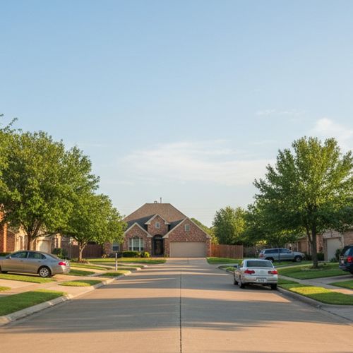
When it comes to daily driving, North Richland Hills relies on a solid, well-planned network of highways and wide local roads. Loop 820 runs right along the southern edge of the city, acting as your main gateway to the wider interstate system. From here, it is a quick merge onto major arteries like I-35W, which opens up the entire region for longer road trips or cross-metroplex commuting.
If you need to travel east toward Dallas or the international airport, you will likely hop onto TX-183, commonly known around here as the Airport Freeway. It is highly efficient and makes East-West travel an absolute breeze. Having this kind of immediate highway access is a major factor when buyers are looking for the best neighborhoods for commuters in NRH.
For your local errands, grocery runs, and weekend shopping trips, you will spend most of your time on the main internal thoroughfares. Davis Blvd, which you might also see on maps as FM 1938, alongside Rufe Snow Drive and Mid Cities Blvd, form the backbone of the city's local traffic flow. They are wide, well-maintained, and packed with local businesses and dining options, making it simple to grab exactly what you need without ever needing to jump on the main highway.
Public Transportation: Riding the TEXRail
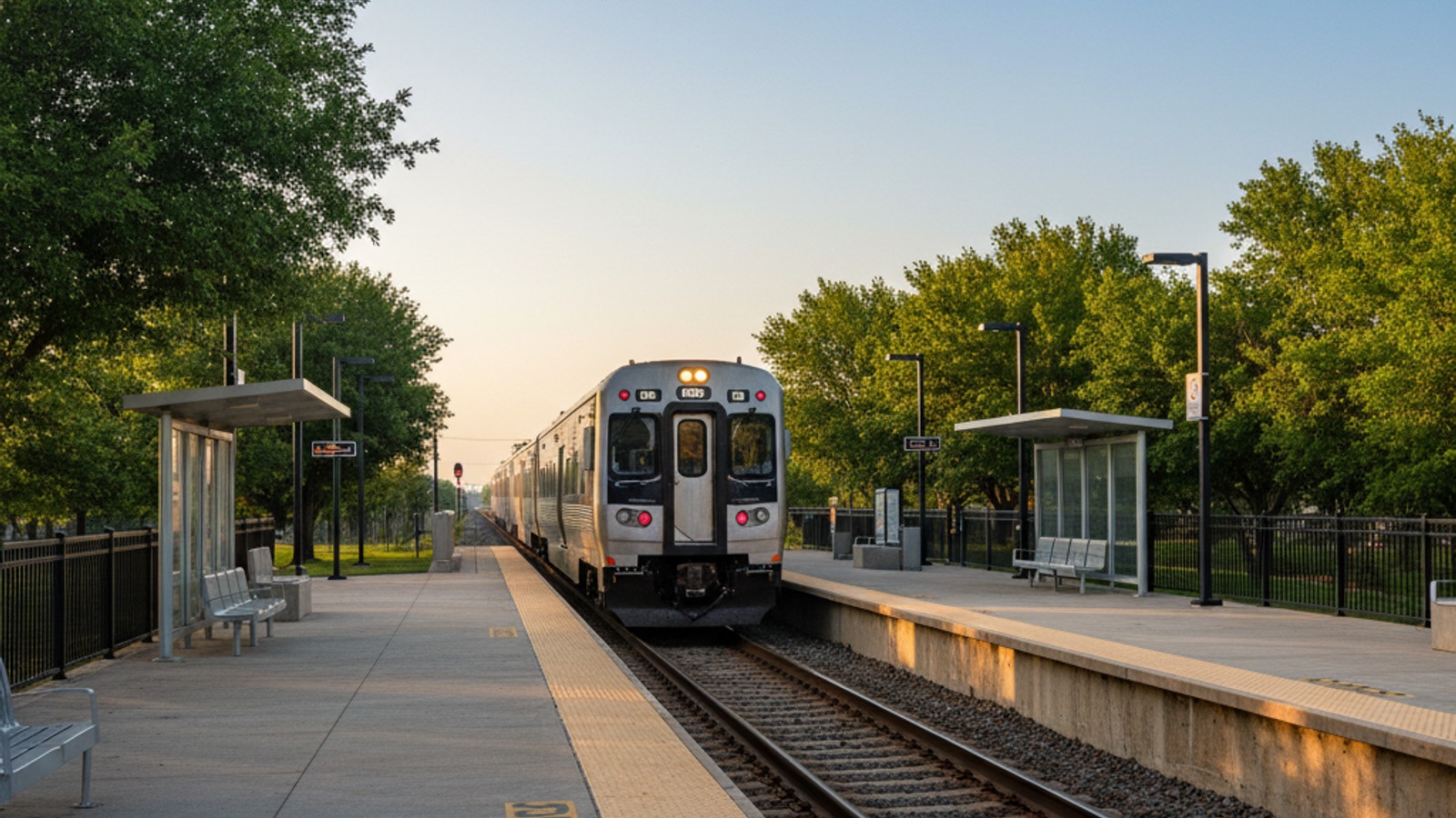
If you want the option to leave the car in the garage, you are in luck. The TEXRail commuter rail service is a massive asset for local residents and completely changes the game for public transportation in the area. Operated by Trinity Metro, this modern rail line offers a quiet, Wi-Fi-enabled ride that turns a stressful morning drive into a relaxing commute.
North Richland Hills boasts two beautifully maintained local train stops - Iron Horse Station at 6351 Iron Horse Blvd and Smithfield Station at 6420 Smithfield Rd. These stations offer direct, stress-free routes straight into Downtown Fort Worth or right up to Terminal B at Dallas Fort Worth International Airport. It is a fantastic perk for frequent flyers, corporate travelers, or anyone working in the downtown sector.
The pricing is also incredibly reasonable for daily commuters. You can expect to pay approximately $2.00 to $2.50 for a standard one-way ticket, or you can grab a local day pass for about $4.00 to $5.00. If you are flying out of town for the weekend, both stations offer long-term parking for just $5.00 a day, which is a fraction of what you would pay when navigating DFW Airport parking garages. Exploring homes for sale near Iron Horse Station is a brilliant move if you want to maximize this daily convenience.
Average Commute Times to Key DFW Hubs
Knowing the local roads and rails is great, but you probably want to know exactly how long it takes to get to work. Commute times here are generally very manageable, though they will always fluctuate depending on peak rush hour traffic. Because of the city's central location, you are rarely too far from the action.
Here is a quick glance at estimated travel times from North Richland Hills to major local hubs:
Fort Worth: A quick 15 to 20-minute drive via Loop 820, or a relaxing 25 to 30-minute ride via TEXRail directly into downtown.
Dallas: Usually a 30 to 45-minute drive via TX-183 and Loop 820, though heavy traffic can push that higher. You can also take the TEXRail to Fort Worth and transfer to the Trinity Railway Express for a rail-only option into Dallas.
DFW Airport: A fast 15 to 20-minute drive down the Airport Freeway, or roughly 20 to 30 minutes on the train directly to the departure terminal.
Arlington: A moderate drive south on Loop 820 puts you right in the entertainment district and near major Arlington employers in about 25 minutes.
If you are currently relocating to DFW for work, these predictable travel times make North Richland Hills a highly strategic home base. You have the flexibility to choose between driving and transit depending on the day's traffic reports.
Active Transportation: Walkability and the Cotton Belt Trail
Let's talk about getting around on foot or by bike. Like most suburban communities in the Dallas-Fort Worth metroplex, North Richland Hills is generally car-dependent for daily grocery runs, medical appointments, and typical errands. Most neighborhoods feature sidewalks, but the distances between residential subdivisions and commercial shopping centers usually require a vehicle.
However, the city truly shines when it comes to recreational walking and dedicated cycling infrastructure. The Cotton Belt Trail is a premier local asset, offering a wide, paved, multi-use path that is perfect for cyclists, runners, and pedestrians. About 4 miles of this regional trail run directly through North Richland Hills, providing a scenic route that safely connects the city to neighboring Grapevine without ever forcing you to compete with vehicle traffic. It is a major highlight when exploring parks and outdoor recreation in North Richland Hills.
Additionally, it is worth noting the Northeast Transportation Service. Known locally as NETS, this program offers affordable, door-to-door transit for eligible disabled residents and seniors. This service ensures that active, reliable, and accessible transportation remains available to the wider community, further proving that you do not always need to be behind the wheel to get where you need to go.
Frequently Asked Questions
As a local expert, I get a lot of questions about the logistics of living here. Here are a few of the most common inquiries regarding local transit.
Does North Richland Hills have public transportation?
Yes, the city offers excellent public transit options, primarily through the TEXRail commuter train. With two dedicated stations in town, residents can easily travel across Tarrant County without driving. Additionally, the NETS program provides specialized door-to-door transit for eligible seniors and disabled residents.
How far is North Richland Hills from DFW Airport?
The city is located approximately 15 miles west of Dallas Fort Worth International Airport. You can typically drive to the airport in about 15 to 20 minutes via TX-183. Alternatively, the TEXRail provides a direct 20 to 30-minute ride straight into Terminal B, making travel incredibly easy.
Can I get around North Richland Hills without a car?
While you will likely need a car for most daily errands and grocery shopping, you can certainly manage specific trips without one. The TEXRail makes car-free commuting to Fort Worth or the airport incredibly easy, and the paved Cotton Belt Trail offers miles of safe, off-road paths for cycling.
If you are curious about living in this fantastic, well-connected community, I would love to help you explore your options. Reach out to our real estate team today to view current homes for sale in North Richland Hills and find the perfect spot for your daily commute.
Check out this article next